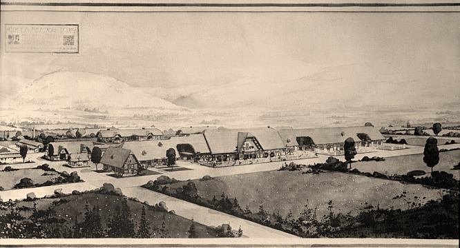
|
Architect's
rendering of the Green Meadow Ranch, ca. 1914. Built by Harry
W. Child (1856-1931), former President of the Yellowstone Park
Company. The 620-acre spread was located along Green Meadow
Drive, just north of the Lewis & Clark County Fairgrounds.
The four
main buildings (house, barn, blacksmith shop and granary) were
designed in a romantic Swiss chalet style by Robert Reamer (1873-1938).
Reamer is best known as the architect of the rusitc Old Faithful
Inn in Yellowstone National Park.
In 1887, Harry W. Child made a financial killing in the purchase
and resale of the land that would become the Green Meadow Ranch.
Acting as trustee for a consortium of Northern Pacific Railway
executives and others, Child purchased the 620 acres for $62,000
in May and June of 1887. It was sold in August to the St. Paul
and Helena Land and Improvement Company for $250,000.
In 1914,
Child bought back the Green Meadow Ranch (under his wife's name)
for an unknown amount. He contracted with Old Faithful Inn architect
Robert Reamer to design the main structures.
The showplace
barn was 450' long, and 40' high. It was constructed of heavy
hand-hewn timbers; the window-frames were hand-carved with fanciful
designs featuring horses heads, birds, etc. The barn had three
cross-passageways, large enough to drive a team and wagon through.
It had three lofts, one of which was sometimes used for dancing.
The residence
burned to the ground in 1924, as did the barn in 1956 -- with
the loss of twenty head of prize stock. The last owner of the
Ranch was Black Angus breeder W. J. Harrer, who sold the land
in the 1970s. It has since been subdivided. Harrer and his wife
were major benefactors of Helena's Grandstreet Theatre.
For more
about the remarkable career of Harry W. Child, visit here.
|
|
DICKERT DAIRY
|
Dennis Dickert has kindly sent in two wonderful photos of the
Dickert Dairy operation, which was in the Helena Valley. He
writes:
Attached
are two photos related to the Dickert Dairy. The panorama
was
taken in 1939 and includes a 1939 small panel truck and
a 1937 large panel
truck. the second image is a close up of the 1937 truck
taken in May 1938.
The
site of the Dickert Dairy was purchased by Fred Dickert
in 1912 and
operation started shortly thereafter. The dairy was in
operation as
Dickert Dairy until 1944 and then became part of McHugh's
Clover Leaf
Dairy.
The
panorama was taken from the east side of the current Helberg
Drive
facing somewhat northwest and shows the original house,
power plant, milk
barn and other out buildings located on the west side
of Helberg Drive.
Helberg Drive can just be seen behind the milk trucks.
The closest
building to the camera, a three stall garage, is still
on the site as are
some of the loafing sheds in the distance.
We
are pleased to have returned this property to Dickert
Family ownership.
It now includes a newer home, barn and outbuildings as
well as 80 acres
which is half of the original site.
|
|
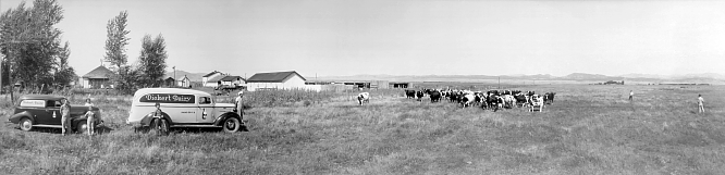
Panorama of the
Dickert Dairy, 1939. CLICK ON PHOTO
TO ENLARGE
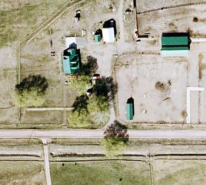
| Recent satellite
photo of the Dickert property, in the same orientation as the
panorama. The 3-stall garage and sheds are still recognizable. |
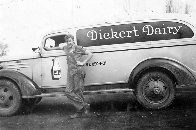
Dickert Dairy
1937 model panel truck, 1938.
|
EHLERS' CORNER
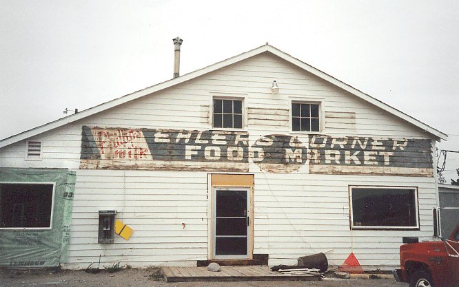
| This building,
at the NE corner of N. Montana Ave. and Sierra Rd. E, is no longer
standing. In the 1950s-60s, it was Ehlers' Corner Food Market,
operated by Ray Ehlers (1893-1970). It then became Martin's IGA.
This photo, showing portions of the old Ehlers' sign, is from
the Charleen Spalding Collection.
She took it shortly after the Martin's IGA sign came down, as
the building was being converted into a restaurant. Thanks, Charleen. |
MASONIC HOME
OF MONTANA
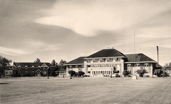
|
The
Masonic Home of Montana, 1940s. Located at 2010 Masonic Home
Road. It was dedicated on September 17, 1908 (see
souvenir ribbon below). At one time, a large collection
of Indian arrowheads and other artifacts was on display in a
room on the ground floor. Is it still there?
|

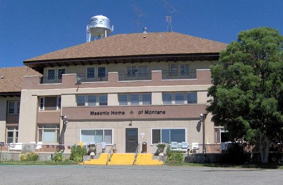
The Masonic Home
as it appears today.
HOME OF PEACE
JEWISH CEMETERY
Helena's
oldest acive cemetery is also the oldest active Jewish cemetery in
Montana
• THE MATERIAL IN THIS SECTION IS ADAPTED FROM
THE HOME OF PEACE NATIONAL REGISTER OF HISTORIC PLACES REGISTRATION
FORM •
COURTESY OF ELLEN BAUMLER
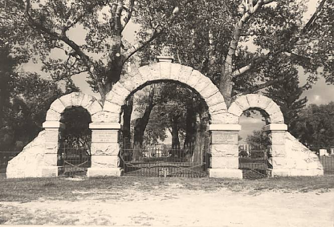
The ca. 1910
front (west) gate, Home of Peace Cemetery
|
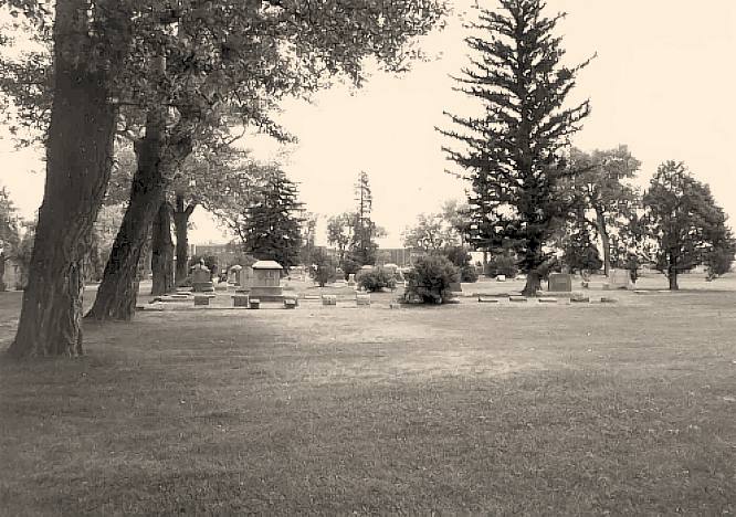
Home of
Peace Cemetery is located near the west side of Capital High
School, south of Custer Avenue, close to the Lewis and Clark
County Fairgrounds. Home of Peace was founded in 1867 by Helena's
Hebrew Benevolent Society.
The Jews who settled in early-day Helena were primarily from
Prussia or Germany and practiced Reform Judaism. They were prominent
in trade during Helena's beginning, and were held in high esteem
by the gentile community. Jews easily partnered with non-Jews
in building and rebuilding the fledgling city. The Montana Club
and the various Masonic orders in Helena welcomed Jews as members.
Such easygoing integration was not the case in other Montana
cities of the era.
On July 11, 1867 Helena's Hebrew Benevolent Society began steps
to acquire a plot of land for use as a cemetery. Prior to establishing
Home of Peace, Jews were buried along with everyone else in
the City Cemetery, which occupied the site where Central School
is today. The bodies of those pioneer Jews were later reburied
at Home of Peace; the others buried there were eventually re-interred
at the Benton Avenue Cemetery.
Helena's Jewish population reached its peak in the 1890s. The
second generation began to move away for better educational
and employment opportunities, and the city's Jewish population
began to decline.
There are inscriptions carved into the central pillars of the
stone gate shown above. The one on the right (south) reads:
"Erected by Morris Sands as a memorial to the sacred memory
of his beloved wife Lizzie who departed this life Jan. 9, 1907".
The inscription on the north pillar reads: "Erected to
the memory of Morris Sands who departed this life Dec. 14, 1910."
|
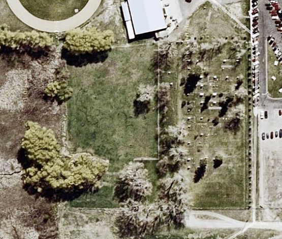
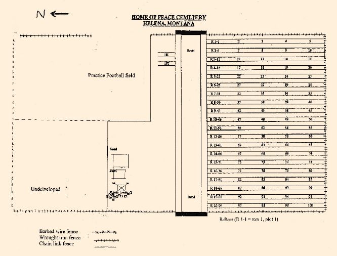
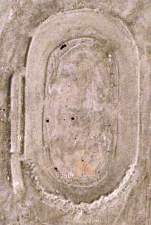
A recent satellite
image of Home of Peace Cemetery, with east at the top.
|
A map of
Home of Peace, in the same orientation as the satellite image.
The structures shown at the bottom left-center are two sheds
(a landscaper's shed and a pump house) and a water tower. The
water tower was supplied by a well until 1921, when The First
Jewish Benevolent and Cemetery Association opted to connect
to the City of Helena water supply.
A few early burials are still in place beneath the area designated
"Practice Football Field", adjacent to Capital High
School, separated from Home of peace by a chain link fence.
Some broken tombstones from burials outside the fence have been
placed near the base of the water tower.
|
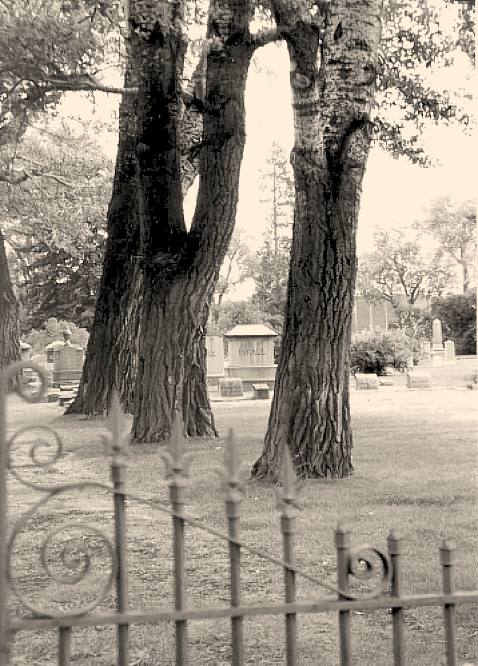
A view through
the gates. The large trees along the driveway were planted in 1910.
Looking east,
inside the gates.
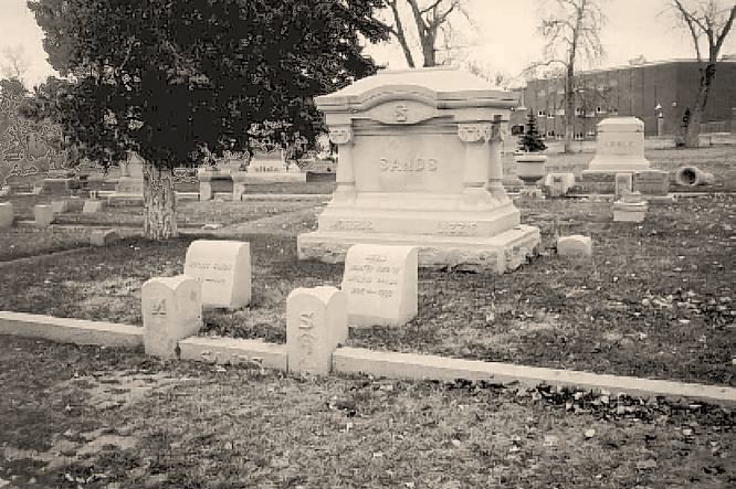
The Sands family
plot.
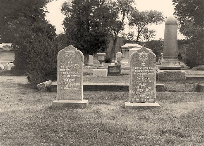
Eisbert and Turk
markers.
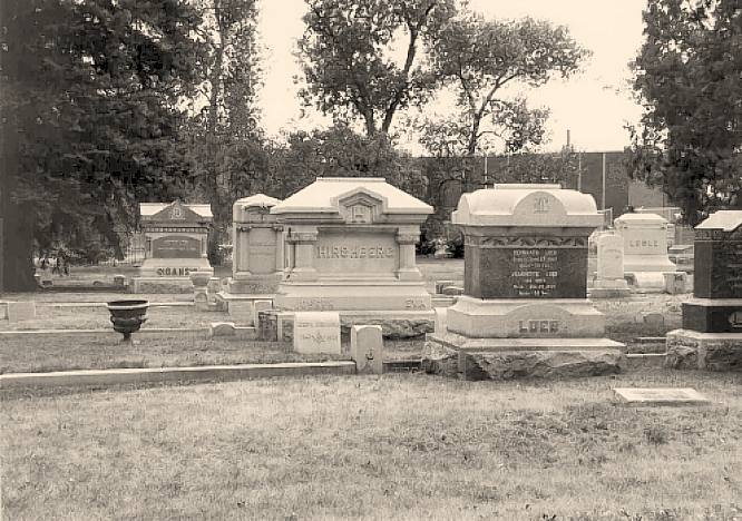
Hirschberg and
Loeb markers.
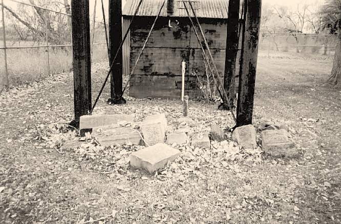
Displaced markers
at the base of the water tower.
|
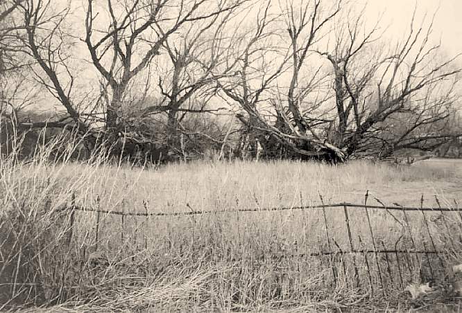
Looking
west at the undeveloped NW section of the cemetery property.
This view shows some of the 1867 wrought-iron fence which still
surrounds most of the property.
The cemetery
is currently administered by The Home of Peace Cemetery Association,
1615 Stuart Street, Helena MT 59601.
|
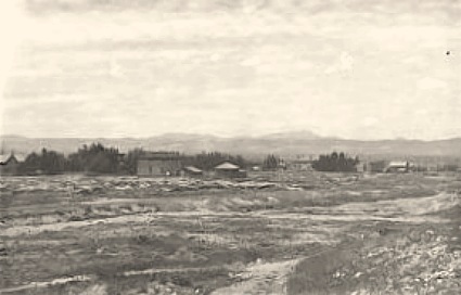
DREDGING FOR
GOLD
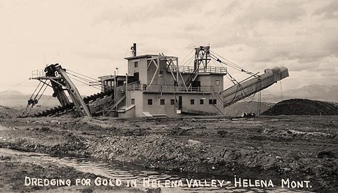
This
is likely the Porter Brothers Corporation's electric Yuba dredge
working the old mine tailings which were north of Custer Ave.
and west of N. Montana Avenue. From November of 1935 to August
1943 the dredge worked continuously on the flats. In that time
45,000 ounces of gold were recovered from gravel that averaged
18 to 30 cents per cubic yard. Dredging stopped in 1943 due
to the war-time restrictions on gold mining. When this ban was
lifted in 1945, the Porter Brothers dredge worked one more season.
Total value of the gold from this dredge was reported to be
more than $2,500,000.
-- INFO FROM THE MONTANA
DEPARTMENT OF ENVIRONMENTAL QUALITY.
|
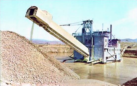
A color view of
the Porter Brothers dredge. Date unknown.
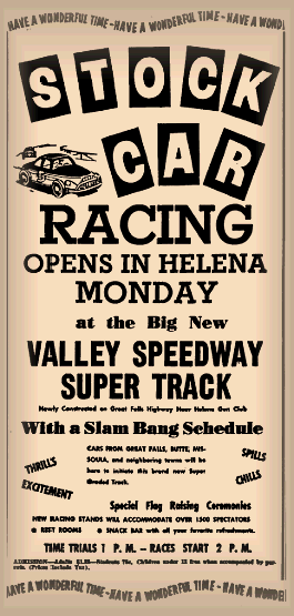
VALLEY SPEEDWAY
|
The home
of the Capital City Stock Car Racing Association, the quarter-mile
banked dirt Valley Speedway opened on May 30, 1955. On
that day, 1,850 fans watched Doug Petersen of Helena win the
"A Main", and thrilled as Don Moe crashed into the
pit separating the track from the grandstand.
In the spring of 2007, what remained of the track was bulldozed
and graded flat, as development began on a new subdivision ("Glacier
Point").
|
|
|
Two recent satellite images showing
the ghost of the Speedway...
|

|
|
|
•
V I D E O •
CLICK ON IMAGE TO DOWNLOAD
|
1972
footage of motorcycles racing at the Valley Speedway,
from the 1973 Helena Chamber of Commerce promotional film
"Helena - City of Gold".
COURTESY OF KITTY
ANN QUIGLEY TAALER |
|
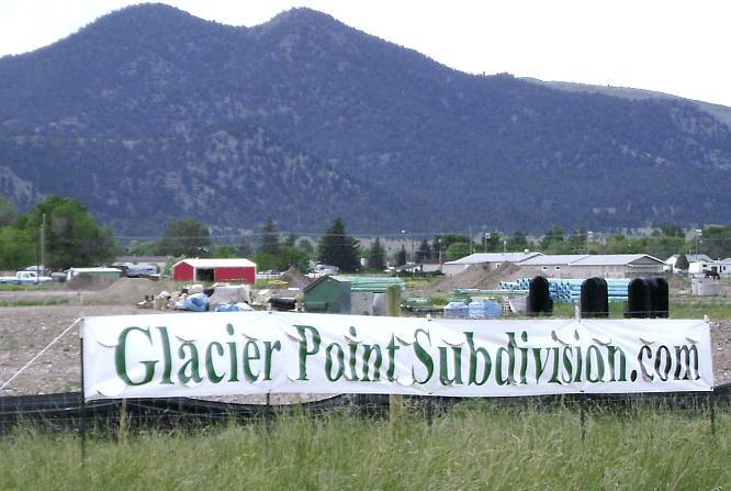
|
June
2007 photo of housing construction at the site of the
Valley Speedway. Photo courtesy
of Tom Kilmer, who wrote:
"Here
is what has become of the Valley Speedway in Helena,Montana.
Another subdivision is
replacing a piece of history. It looks like the entire
track is gone now. I watched the heavy equipment level
the banked corners. Now the piping for water and sewer
is going in."
|
|

|